First Assignment
"Where am I ?"
When you are playing an orientation game/race, you have to recognise some characteristic, noticeable point (or a landmark or an identifiable feature : hill, tower, bridge ...). From those point you are able to check that your are in a given guessed point. More systematically, a GPS system will use triangulation based on satellite position to determine your "exact" coordinates.
In this assignment you will be asked to build a little software that will display on a map your computed position, taking into account the angle from which you see two or more noticeable points. You should refer to the Maths section of the lecture to get some idea about how to compute these guessed positions.
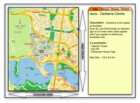
Here is a general idea of the interface of the software :
The assignment will mainly consist of a JFrame with 2 panels. One panel to display the map (and highlight the landmark and possible positions), and one panel to host a set of different sub panels (JTabbedPane), one for each different tools, accessible by the selection of the tabs.
3 default Tab
The general interface should be based on at least 3 default tabbed panes
Pane General information ("Map" ?)
This pane will display as much information as possible from the configuration file. It should display at least
-
The name of the map
-
The general description of the map. Take into account that sometime, that text could be bigger than you would have imagined : you have to decide what sort of limitation you could impose on those text that you display. No need to limit the user, just cut the text or make it scrollable.
-
The number of available landmarks.
-
A short list of some landmarks.
-
The size of the map.
If you think you could add more information, without losing visibility, you may think to add, within that pane, or in an associated popup frame (accessible trough a "more Info" button for instance)
- The name of the description file, and the lat time it has been edited
- The coordinate of the top left corner of the map
- ... whatever you could think of : this part is just a free option anyway ...
Pane List of available landmarks ("What" ?)
This pane will display a list (JList + JScrollPane ?) of the available landmarks and their eventual selection (as being a point A, B, C, D of the measurement). On that pane, you should be able to select and highlight one landmark at a time : in the bottom part of the pane, you will display all what you know about the selected landmark : display of picture(s), description, coordinates, and a modifiable status (comboBox ?) amongst : "not used" or used as being a point "A", "B", "C" or "D". Note that if the user decide that a selected landmark should be the point A, and if another landmark A had been set previously, then the previously set landmark status return automatically to the "not used" type.
At the same time, when you select a landmark, it should be highlighted on the map, either by a pulsing circle, a cross, whatever suits your GUI design ... and its status should be set close to it (or by using a ToolTip ?). NB. Even without selecting them, there should be a discreet sign to locate them on the map as soon as you load the map.
The possible status should take into account the state of the "3 or 4" points option specified in the "Estimation" Pane (see next)
Pane Estimation of Position ("Where" ?)
This is the panel where the result are displayed !
First there is a option to select : will you use 3 or 4 landmarks (what "3" really means, is that B and C will be the same landmark)
Then, there is two way to select the landmarks, either by selecting them in the previous Pane, or by selecting them on the map, from that pane. The process is the following. You use a radio button to specify which of A, B, C or D you will select, then you click on, or close enough to a landmark to select it. If case of the "3" option, the C area is gray and can not be activated.
There will be two field that will allow you to specify the Angle you see from your position between A and B and then between C and D (4 points option) or between B and D (3 points option).
As soon as the application detect that 2 point and and the matching angle is specified, it should compute the possible set of position and display it, visually on the map (matching arc of circle) and on the pane (origin coordinates and radius).
When both 2 sets (points and angle) are set, one should get
displayed both the final point on the map and the coordinate on the pane.
If you deselect any point, the matching information should of course be deleted
from the map.
Ground Rules for all projects:
- The design and coding must be your own. There is plenty of room for originality.
- Don't use code from previous semesters.
- Should I remind you of the importance of a code well presented and documented ?
- Cite any models, images, ideas, or algorithms that you do not develop yourself.
- Project is due before midnight of the day indicated : 9th September 2003.
- Please read this text through to the end before touching any keyboard.
- Take time to think before you touch your keyboard
- Then before beginning the project, have a look at this document on the web
page : you will find some useful links like the one to the README
file model.
To submit a project ...
you should put altogether, in a directory called CG_A1_03_UstudentID...
(Where 'studentID'...is your student ID !... CG_A1_03 means the first assignment in Computer Graphics lecture of the year 2003)
- Your well commented Java source file(s)
- Your compiled classes
- The documentation generated by javadoc
- A 'README.html' HTML file that should summarise and/or describe (it is
your report file and is important in the marking)...
- all that is available in your directory
- the options you have chosen to implement (there should be at least 2 of them)
- how to use your program
- the command line options
- the GUI
- the way you have implemented the algorithm (tricks that are particulars to your work)
- one or more screen shot of your program (that shows both the tree and the GUI)
- a link to the generated documentation
Here is its README.html file template
Use the jar command to put your directory into a single jar file based on the same name and mail this file to pascal.vuylsteker@anu.edu.au
cd .. (go to the directory in which your CG_A1_03_UstudentID is located)
jar cvf CG_A1_03_UstudentID.jar CG_A1_03_UstudentID/
Mail the file (CG_A1_03_UstudentID.jar) as an attached document. Be sure that the title of your mail is 'CG_A1_03_UstudentID''
!!! Your jar file should not be more than 500 kB !!!
The minimum requirements
Your project should be composed of, or respect, at least, the following :
(1) 3 different well balanced main classes (there could be of course more, but there should not be more than 15 classes for this size of project). Explain in the README file what the role of the 3 classes are.
(2) One of the classes should be a public class, whose name will be "Assignment", and will contain the "main method" in such a way that, to test your project, I will only need to call 'java Assignment [command line arguments]' to run it. Because yours classes will be well documented, I should be able to write that "Assignment" class by myself without to much work.
(3) You will explain the use of the arguments in your README file but the main one (and the first) will be the name of a map description file such as the one I will use to test your program : canberraCenter.vot ('.vot' like Virtual Orientation Table). Any map used by your program will be fully described by a similar text file, and its associated images (of the map itself and of some associated landmark). The full set of data that will be potentially used for this assignment is visible here, and downloadable here. You may find useful to have a look at the following tip.
N.B.: Don't cheat, your program should really read that file. For the marking I will use a very similar file, but with some different information and landmark points ...
E.g. : java Assignment canberraCenter.vot
will load the description file canberraCenter.vot and its associated
images and display the map and related information on the first JPanel.
(4) By default, the opening window should be well positioned (you should see it entirely, but it should not use all the screen space, between half and 2/3rd of the space) whatever is the size of the screen.
(5) Remember that sometimes, users may be dumb and may not use the right number of arguments, or the good one. You should deal with that sort of situation.
(6) One peculiarity of these map displays is that the Frame should be resizable (whenever the size of the window is changed by the user, the map should always be at least partly visible and you should be able to move around my using sliders).
(7) The compile classes should be available at the root of your directory. During the marking process, I may :
- unjar your jar file (jar xvf...)
- cd into your directory (all the file should be in your directory or in subdirectories and should not mess with my working directory !)
- run 'java Assignment myPath/canberraCenter.vot'
- del *.class
- javac *.java
- and keep doing other sort of tests ...
(8) Some special case / situations you have to think about
- what if the measured angle between two points is close to 180° ?
- what if you select twice the same couple of landmark (and perhaps in the opposite order)
(9) You should try to detect, as far as possible, when the user has made some measurement error (typically, if there is no intersection between the two circles !) and politely suggest to do the measurement again
(10) When you move your mouse close to a landmark point, a circle of a special colour surround it and if you click within that circle, you select that point (even if you are not exactly above it).
(11) A menu with t least two items will allow you :
- to Quit the application
- to Load a new map (by choosing another '.vot' file)
(Not So) Optional Development:
You should do at least two of the following options to get the maximum mark
- Panel Case 2 landmarks
2 landmark and two horizontal angles with well-known cardinal direction (angle between the North and the landmark) - Panel Case 1 3d landmark
1 3D landmark, 1 3D direction, one height field : Raytracing - Panel Error
On that panel, you will compute and highlight of the effect of error on the measurement to the computed position : You modify the two measured angle by a small value (in both direction, and you compute the position for each matching set of value : you get an area that define - Panel VOT
When I look at a given direction (that I should be able to interact with by using a slider) within a given angle of view (modifiable by a slider too, between 0 and 180%), what are the landmark visible to me, how far away are they from me? - Panel Modification
Addition of new landmark to the terrain, modification of existing one, or general description of the map, and saving of the map file - Panel computer vision :-)
If you load an image of what you think should be a landmark, the soft will look at the existing landmark database and propose you picture (and therefore landmark) that looks like the one you just propose. - Half Option : Menu Colour
A menu that allow you to specify all the colour and thickness of drawn used within the soft (one colour/thickness to display the landmarks, one do display the selected landmark, one to display the arc of circles, one to display the computed position - Half Option : Panel Measurement
If you select a point or a landmark, you get its coordinates
If you select a second point or landmark, you get both coordinates and the distance between the 2 locations
If you select a third point or landmark, you get both coordinates, two distance, and an angle
N.B.: a "landmark" is a point already listed in the list of landmarks, a "point" is any point on the map - Half Option : Menu Switch format
A menu that switch the display of all the coordinates used in the GUI between 3 possible modes :- meter/km from the top left corner of the map (the display of either m or km should be in function of the value, given than the precision is supposed to be of 3 digits (1123 m ~= 1121 m => is displayed 1.12 km , but 993 != 992 => is displayed 993 m
- pixel from the top left corner of the map
- absolute (latitude, longitude) (explain down to what level you are suppose to go when it come to the precision
- XML format
Option that could be chosen only as a second one with the "Panel Modification" one : XML.
You should be able to load and save the description of the map as a XML file. You will have to propose a DTD that encompass the description available in the proposed default format, and the user should be able to combine the edition/saving and loading from and to (and any combination) the two formats : default and XML one.
Penalties for late submission:
Late submission may be penalised at 10% per day late.
Bonus for early submission : 1 mark if the assignment is send at least one day before the due day (therefore before the 8th of september at 2359).
Additional Map :
http://www.palm.act.gov.au/tplan/gridfram.htm